 Germany's Federal Association for Final Storage (BGE - Bundesgesellschaft für Endlagerung) has identified a second research area for investigating terrestrial and airborne geophysical exploration methods. BGE’s GeoMetEr research project aims to develop new measurement methods to help with the minimally invasive exploration of regions selected as suitable for a high-level radioactive waste repository.
The €8.8m ($9.5m) GeoMetEr project, which has been running since March, is being implemented by BGE along with nine project partners. It is scheduled to continue until the end of March 2028. The partners include: TU Bergakademie Freiberg, Leibniz-Institut für Angewandte Geophysik, Westfälische Wilhelms-Universität Münster, Leibniz-Institut für Photonische Technologien, DMT GmbH & Co, terratec geophysical services GmbH & Co, Supracon, Solexperts, and Bundesanstalt für Geowissenschaften und Rohstoffe. The project is accompanied by an external expert advisory board.
Geophysical measurements within the GeoMetEr project will be realised in two research regions representing different types of potential host rocks for high-level radioactive waste - crystalline and clay rock. The first research region is located near the municipality of Langenweißbach in the Ore Mountains and builds on a previous research project by the Technical University Bergakademie Freiberg.
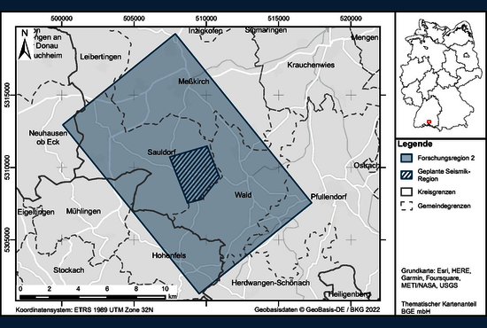
BGE has now named the exact layout of the second research region in the south of Baden-Württemberg. It measures around 150 square kilometres and extends across the municipalities of Sauldorf and the neighbouring regional authorities of Wald, Herdwangen-Schönach, Meßkirch, Pfullendorf, Leibertingen in the Sigmaringen district; Mühlingen and Hohenfels in the Konstanz district; and Neuhausen ob Eck in the Tuttlingen district.
The graphic shows a map on which the research area for GeoMetEr in the south of Baden-Württemberg is shown. A rectangle shows the affected counties. There is a smaller area with a hatching in the rectangle. A 3D seismic is to be carried out there.
A criterion for the selection of the research regions was that they should be already excluded from the search for a repository site. Both research regions are located in areas that are unsuitable as a future repository location according to the exclusion criteria specified in the site selection law. They are therefore no longer considered by the BGE in the further search procedure. The Sauldorf research region was excluded because of seismic activity and the Langenweißbach research region because of active fault zones and influences from current or previous mining activity.
The planned studies are structured into two phases for both regions. In the first phase, terrestrial and airborne exploration with different geophysical methods is performed on different scales. In the second phase, the results from both research regions are supposed to be verified by geophysical measurements and additional tests in research boreholes.
In March 2023, the University of Münster carried out the first test measurements in the Sigmaringen district of the Sauldorf region to assess the influence of potential EM noise sources, such as transmission towers. This information will be used to define a research area for testing further exploration methods. BGE determined the 150 square kilometre research region also taking into account local geology and possible protected areas.
Various geophysical measurement methods are to be tested in the Sauldorf research region by 2027. These include 2D seismics as well as magnetic and electromagnetic measurements from the air. In addition, BGE plans to determine a 25 hectare area together with its project partners in a next step, in which a high-resolution 3D seismic and a research well up to 600 metres deep will be carried out. In addition, the testing of magnetic and electromagnetic measurements with helicopters and drones is planned in autumn 2023.
The first magnetic and electromagnetic measurements from the air as well as the first seismic measurements are planned in the Langenweißbach research region from winter 2023.
BGE is a state-owned company in the division of the Federal Ministry for the Environment. In 2017, BGE took over responsibility as operator of the Asse II mine and the Konrad and Morsleben repository from the Federal Office for Radiation Protection. As well as investigations related to siting a high-level waste repository. The selected site would store about 1900 containers of waste, which account for 5% of Germany's total nuclear waste but 99% of its radioactivity. A final decision is scheduled for 2031 with the aim to start using the selected site in 2050.
In September 2020, BGE published a list of potential storage sites in Germany for radioactive waste. It identified 90 areas covering 54% of the country's surface area as potentially geologically suitable. The report excluded a site at a former salt mine in Gorleben that was previously thought suitable. BGE is now responsible for decommissioning the Gorleben mine.
Image: Map of the GeoMetEr research region in southern Baden-Württemberg. The hatching shows the planned seismic region. The other research region is located in Langenweißbach in Saxony (courtesy of BGE)