
An intelligent forest fire prevention system has been put into operation at China’s Ningde NPP in Fujian province, marking the station’s transition to a new stage of digital transformation based on data management, intelligent perception and closed-loop response.
This system, using the latest information technologies, creates an intelligent fire barrier covering the entire territory, ensuring accuracy and high efficiency. It implements the integration of forest fire monitoring, prevention and management at several levels – long-range, medium, short-range and high, medium, low.
The monitoring and early warning system at the long-range level relies on multi-satellite constellation technology to provide 24-hour, high-frequency dynamic fire detection. Thanks to the coordinated work of 18 operating satellites, the entire territory is scanned every 10 minutes, a forest fire perception network is formed with high spatiotemporal resolution, with a special emphasis on covering the corridors of the main power transmission lines with voltages of 500 kV and 220 kV of the NPP.
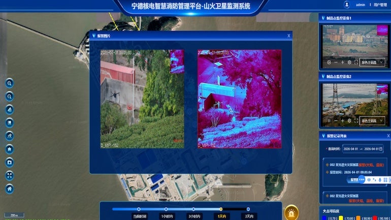
At the medium level, unmanned aerial vehicles (UAVs) are used for regular patrols along given routes. At the short-range level, video surveillance from command points is used, as well as an intelligent fire recognition mechanism based on artificial intelligence to determine the location of outbreaks real-time propagation directions and intensity of thermal radiation. This helps prevent equipment shutdowns and line shutdowns due to forest fires, creating a strong digital barrier to the safe operation of the power system.
At the data acquisition level, the system deeply integrates high-quality two-spectral imaging technology and deep learning algorithms of peripheral AI. It is equipped with intelligent monitoring terminals with ultra-low light imaging capabilities, providing stable recognition and precise positioning in challenging environments such as night, fog and low light. Fire detection accuracy consistently exceeds 99%, which significantly increases the ability to identify risks in difficult conditions and contributes to the transition from traditional manual patrols to automated and intelligent monitoring.
At the management level, the system is built on the basis of an information platform using digital twin technology, covering all elements. It dynamically displays outbreak timing, precise geographic coordinates, associated support numbers, surrounding vegetation distribution, and history of previous fires. It automatically generates structured analytical reports, providing tracked and quantitative data support for operational decisions.
With the intelligent alert mechanism and API (Application Programming Interface)-level emergency response mechanism, alerts can be transmitted to operational personnel’s end devices in seconds, enabling seamless integration with the GIS (Geographic Information System) platform, dispatch system and emergency management system. This forms a completely closed digital control process: comprehensive perception – intelligent warning – precise task distribution – processing and feedback – performance assessment, making the transition from passive response to active prevention.
The official commissioning of the satellite monitoring system for forest fires is a milestone on the path towards the modernisation of energy infrastructure security management driven by digital transformation and technological innovation. The system not only significantly improves the speed of response and effectiveness of measures to prevent forest fires on power lines, but also creates a replicable and scalable technological paradigm of intelligent fire protection for the electricity industry. It provides reliable technological support for the safe and stable operation of power units and maintaining the security of regional energy supplies.


